Contents
Index
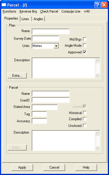
Parcel Properties
The Parcel Properties Menu is separated into two sections. The top section is for plan data and the lower section is for parcel data.
NT parcel Values
Plan Data
Name
This is the Plan identifier. The plan name is used to uniquely identify a plan in the cadastral system.
Even though each plan is unique, a plan can have more than one parcel attached to it.
Survey Date
The survey date is the date stated on the plan.
It can be entered in a number of ways. The date should be entered either as a six digit field '281172' (DDMMYY), an eight digit field '28111972' (DDMMYYYY) or in the following format, 28-11-1972 (DD-MM-YYYY).
The program will check the date and display it in a standard format 28-11-1972.
The survey date is used by the adjustment to provide a default estimate of accuracy for all lots entered on the plan. The reason the survey date is used to estimate the plan accuracy is because survey accuracy has improved with technology and survey practice improvements.
Units
The units used for plan dimensions can be selected from a drop down box.
The options are:
Metres
Feet
Links
US Feet
Description
Any additional information that is associated with the plan can be written here.
Mid Brgs
Select this if the bearings on the plan are "True Mid Bearings".
A true mid bearing is the clockwise angle measured from the centre point of the line between true north and the end of the line.
It is mainly used for large parcels in remote areas. See True Mid Bearings for more information.
Angle Mode
Use this to indicate whether angles or bearings are used to define the direction of lines. See Angle Mode for more information.
Approved
This identifies that the plan being entered is an Approved plan.
The program will default to having this checkbox already un-selected.
If the plan you are entering is an Unapproved plan, the checkbox will need to be unselected.
Extra
Click on this to be able to enter "Extended Attributes" associated with the plan. See Extended Attributes for more information.
Parcel Data
Name
This is the Parcel identifier. The parcel name is used to uniquely identify a parcel in the Plan.
Even though the program will allow more than one parcel on a plan to have the same name, it is recommended, to avoid confusion, that each parcel is named with a unique name.
Example: if there are 2 parts of Lot 12, it would be less confusing to name the parcels 12Pt1 and 12Pt2 rather than to have 2 parcels both named lot 12.
UserId
The UserId is a data field which can be used to enter a user assigned identifier to a parcel.
It can be a tax number or any identifier which may assist to identify the parcel.
The UserId can contain both alpha and numeric digits.
Stated Area
The Stated Area is the legal area of a parcel as shown on the plan.
In some older subdivisions, the practice was to understate the area so that the area stated on the plan is actually smaller than the area calculated by using the parcel dimensions.
For most cases a single character suffix is used to identify the area units:
- a = Acres
- r = Roods
- p = Perches
- m = Metres
- h = Hectares
- sqm = Metres
- sqkm = Square Kilometres
- SqMiles = Square Miles
Using suffixes other than these may result in invalid area calculations when "Check Parcel" or "Close Lot" are selected in the lines grid after data entry.
Tag
The parcel tag is a number in the range 1-999 to indicate the type of parcel being entered.
Usually the government authority in your area will require that the parcels are tagged. For information on parcel tags, see Parcel Tags
Accuracy
The order of Accuracy is a number between 1 and 6 indicating the category of the data. See Accuracy Rules
This field can be used to override the default accuracy, which is set from the Survey Date of the plan.
If this field is left blank, then the plan date sets the accuracy. For information on data accuracy and weightings, see Adjustment Weighting
Description
Any additional information that is associated with the parcel can be written here.
Joined
This field is greyed out so that the user cannot modify it.
The program automatically selects and de-selects this field when the parcel is joined and unjoined.
Historical
Tick this box if the parcel is considered ‘historical’ or not current.
When a subdivision is done, the original parcel (assuming no residue) is usually marked Historical, as it no longer represents the current parcel boundaries.
By marking the original parcel 'Historical', there is no need to unjoin this parcel to join the new parcel. The new parcel can be joined on top of the original parcel so that the file remains a complete cadastral model which can show both the current parcels as well as the historical parcels.
The Historical parcels can either be viewed or made to be invisible by selecting or de-selecting the checkbox in Display Settings.
Compiled
This field is used to indicate that the data has been compiled from previous plans and does not represent a survey carried out on the plan date.
Without other information (such as explicitly setting the accuracy), compiled plans will assume an accuracy of plans prepared in 1900, which is an accuracy 5.
Unclosed
Tick this box is the parcel is not a closed polygon.
This box should also be ticked if entering the centreline of an easement etc. See Entering Easements for more information.
Extra
Click on this to be able to enter "Extended Attributes" associated with the parcel. See Extended Attributes for more information.